My way point : Différence entre versions
| (17 révisions intermédiaires par 3 utilisateurs non affichées) | |||
| Ligne 1 : | Ligne 1 : | ||
{{Languages|"Mon WP"}} | {{Languages|"Mon WP"}} | ||
| − | This option gives you the | + | This option gives you the ability to have your own way point. |
| − | If no value | + | If no value has been filled, your Way point (WP) is the next mark, provided (lat,lon) are entered as '0'. |
| − | When you fill a value (lat, lon) | + | When you fill a value (lat, lon) in the 2 WP text boxes, the next race mark is forgotten until you reach your waypoint. |
| − | As a race mark, WP can be used with the following modes : '''Orthodromics pilot''', '''best VMG''' and '''VBMG''' ('''Constant heading''' and '''Constant Wind Angle''' don't use the WP. | + | As a race mark, WP can be used with the following modes : '''Orthodromics pilot''', '''best VMG''' and '''VBMG''' ('''Constant heading''' and '''Constant Wind Angle''' don't use the WP). |
| + | |||
| + | Race mark coordinates can be found into Course instruction or on top right of the UI when mouse navigates over mark number (see screenshot). | ||
| − | |||
[[Image:wp_depart_exemple.png]] | [[Image:wp_depart_exemple.png]] | ||
| − | + | ''Explanation '' | |
| − | + | * ''Departure is on 50°33'40"N 001°14'4"W '' | |
| + | * ''One race mark is on 51°23'03"N 009°36'00"W'' | ||
| + | * ''Final mark is between 50°17'24"N 004°10'47"W and 50°15'00"N 004°04'48"W)'' | ||
| − | + | In our example, as the race has not started yet and the boats are still on the starting line, the WP is 51 ° 23'03 "N 009 ° 36'00" W 319.26 nm located at 282.1 great circle as indicated on the dial. | |
[[Image:VLM_MonWP_defaut2.png]] | [[Image:VLM_MonWP_defaut2.png]] | ||
| − | + | To program the next WP to be the same as the coordinates of the next mark, you must enter the value 0 into the boxes Lat and Long as in the picture below. | |
[[Image:VLM_MonWP_defaut1.png]] | [[Image:VLM_MonWP_defaut1.png]] | ||
| − | + | But with the next WP as the next mark, if you program the pilot for better VMG, you will become Grounded for sure, with a penalty guaranteed, as seen easily from the inboard course image below. | |
[[Image:071228fastnet.png]] | [[Image:071228fastnet.png]] | ||
| − | + | Alternatively and more safely we should choose a suitable WP to circumvent the tip of Lizard (approximately 49 ° 57'N 005 ° 12'W). With a little caution, so as not to bump into the Point, the southernmost tip of Plymouth, retain 49 ° 48'N 005 ° 12'W. This entry is in decimal degrees, or 49.8 and -5.2. For the record, we must divide by 6 (= 1 ') the number of minutes, same for seconds. | |
[[Image:VLM_MonWP_perso1.png]] | [[Image:VLM_MonWP_perso1.png]] | ||
| − | + | Save | |
[[Image:VLM_MonWP_perso2.png]] | [[Image:VLM_MonWP_perso2.png]] | ||
| − | + | and the result is visible on the dial | |
[[Image:VLM_MonWP_perso3.png]] | [[Image:VLM_MonWP_perso3.png]] | ||
| − | + | WP is 158.58 nm cap ortho 254.8 | |
| − | + | On the map you can see the WP and indicated route. | |
[[Image:VLM_MonWP_perso4.png]] | [[Image:VLM_MonWP_perso4.png]] | ||
| − | + | So we can use the driver circle and better VMG to fail safe (if the winds do not change completely and send us all on the coast anyway (however is nature of the routing and mode of use of instruments). | |
| − | + | The parameter @ WPH can choose the exact course to follow once the WP staff (My WP) is triggered. | |
| + | If enabled, the boat will take the selected course from the passage of the WP staff (see image below). | ||
| + | This piloting alternative is very useful when passing between islands and tight areas. | ||
| − | |||
[[Image:WPH.png]] | [[Image:WPH.png]] | ||
| − | Important : | + | Important: The system considers a WP be reached when the distance between the boat and the WP is less than 1/12 the speed of the boat at the last session, approximately the distance traveled during the last session (eg, with a speed of 24 knots, the boat will reach the WP when the waypoint will be located within a circle with a radius of 2 miles ranging from the WP). Recent information is valid for racing with "vac" every 5 minutes (for races other "vac" should be adapted as appropriate) |
| − | |||
[[Catégorie:VLM]] | [[Catégorie:VLM]] | ||
catégorisation | catégorisation | ||
Version actuelle datée du 8 mars 2013 à 11:14
This option gives you the ability to have your own way point.
If no value has been filled, your Way point (WP) is the next mark, provided (lat,lon) are entered as '0'. When you fill a value (lat, lon) in the 2 WP text boxes, the next race mark is forgotten until you reach your waypoint.
As a race mark, WP can be used with the following modes : Orthodromics pilot, best VMG and VBMG (Constant heading and Constant Wind Angle don't use the WP).
Race mark coordinates can be found into Course instruction or on top right of the UI when mouse navigates over mark number (see screenshot).
Explanation
- Departure is on 50°33'40"N 001°14'4"W
- One race mark is on 51°23'03"N 009°36'00"W
- Final mark is between 50°17'24"N 004°10'47"W and 50°15'00"N 004°04'48"W)
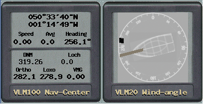
In our example, as the race has not started yet and the boats are still on the starting line, the WP is 51 ° 23'03 "N 009 ° 36'00" W 319.26 nm located at 282.1 great circle as indicated on the dial.
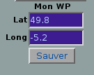
To program the next WP to be the same as the coordinates of the next mark, you must enter the value 0 into the boxes Lat and Long as in the picture below.
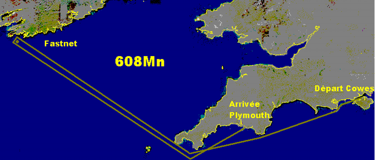
But with the next WP as the next mark, if you program the pilot for better VMG, you will become Grounded for sure, with a penalty guaranteed, as seen easily from the inboard course image below.
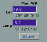
Alternatively and more safely we should choose a suitable WP to circumvent the tip of Lizard (approximately 49 ° 57'N 005 ° 12'W). With a little caution, so as not to bump into the Point, the southernmost tip of Plymouth, retain 49 ° 48'N 005 ° 12'W. This entry is in decimal degrees, or 49.8 and -5.2. For the record, we must divide by 6 (= 1 ') the number of minutes, same for seconds.
Save
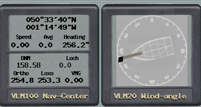
and the result is visible on the dial
WP is 158.58 nm cap ortho 254.8
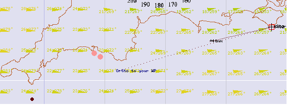
On the map you can see the WP and indicated route.
So we can use the driver circle and better VMG to fail safe (if the winds do not change completely and send us all on the coast anyway (however is nature of the routing and mode of use of instruments).
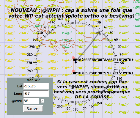
The parameter @ WPH can choose the exact course to follow once the WP staff (My WP) is triggered. If enabled, the boat will take the selected course from the passage of the WP staff (see image below). This piloting alternative is very useful when passing between islands and tight areas.
Important: The system considers a WP be reached when the distance between the boat and the WP is less than 1/12 the speed of the boat at the last session, approximately the distance traveled during the last session (eg, with a speed of 24 knots, the boat will reach the WP when the waypoint will be located within a circle with a radius of 2 miles ranging from the WP). Recent information is valid for racing with "vac" every 5 minutes (for races other "vac" should be adapted as appropriate) catégorisation
