QtVlm meteo faxes : Différence entre versions
| Ligne 9 : | Ligne 9 : | ||
Even better, you can compare it with the loaded grib.<br> | Even better, you can compare it with the loaded grib.<br> | ||
| − | Meteo faxes have a huge interest: they are drawn and validated by real, human meteorologists who use all their experience and | + | Meteo faxes have a huge interest: they are drawn and validated by real, human meteorologists who use all their experience and many sophisticated tools that are not available to us. The meteorologist commits himself.<br> |
A lot of these meteo faxes are available on internet.<br> | A lot of these meteo faxes are available on internet.<br> | ||
| Ligne 15 : | Ligne 15 : | ||
When at sea, these faxes were arriving or are still arriving via BLU reception<br> | When at sea, these faxes were arriving or are still arriving via BLU reception<br> | ||
Now, they can arrive as an attachment to an email, via Irridium or Inmarsat for instance.<br> | Now, they can arrive as an attachment to an email, via Irridium or Inmarsat for instance.<br> | ||
| − | |||
= Where to find meteo-faxes? = | = Where to find meteo-faxes? = | ||
Version actuelle datée du 19 avril 2012 à 11:49
Sommaire
Foreword
A meteo fax is a conventional meteo map. Traditional way.
In its modern form, it is no longer printed on paper but it is an image file in one of these common formats .gif, .tif, .jpg, etc.
In these formats, it can be loaded and displayed on a computer with many different software.
You can also read it with qtVlm.
Even better, you can compare it with the loaded grib.
Meteo faxes have a huge interest: they are drawn and validated by real, human meteorologists who use all their experience and many sophisticated tools that are not available to us. The meteorologist commits himself.
A lot of these meteo faxes are available on internet.
When at sea, these faxes were arriving or are still arriving via BLU reception
Now, they can arrive as an attachment to an email, via Irridium or Inmarsat for instance.
Where to find meteo-faxes?
For North Atlantic, here (NOAA): http://www.opc.ncep.noaa.gov/Atl_tab.shtml
For North Pacific, here (NOAA): http://www.opc.ncep.noaa.gov/Pac_tab.shtml
Almost all images are available here (NOAA): http://www.opc.ncep.noaa.gov/shtml/ .
If you use a costly satellite connection, you can also receive very light meteo faxes via mailasail.com with requests like these:
48H
weather@mailasail.com - Objet : QDTM85.SMALL.TIF
96H
weather@mailasail.com - Objet : PWAM99.SMALL.TIF
To be completed
Frequencies and time schedule for BLU emission for the whole world and even more (pdf format):
http://www.nws.noaa.gov/om/marine/rfax.pdf .
This document is very complete and up-to-date. A gold mine
Note :
If you know other sources, thanks for indicating them here
Opening a meteo-fax with qtVlm
- Menu Grib File > Meteo faxes > Open/Close
- Click on Browse and select a file. OK.
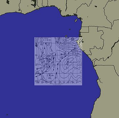
An image file (gif, tif, jpg, etc.) does not contain any localization data. Therefore the map is loaded by default centered at latitude 0° and longitude 0° (in the Guinea Gulf). It is displayed in a square of 600 nm, and at first is out of scale and not correctly displayed.
The user has to position correctly this map.
- Repositionning the meteo-fax:
- Shift-Clic and drag to move the meteo-fax,
- Ctrl-Clic (Cmd-Clic under Mac OS) and drag to resize it,
- Alt-Clic and drag to adjust transparancy.
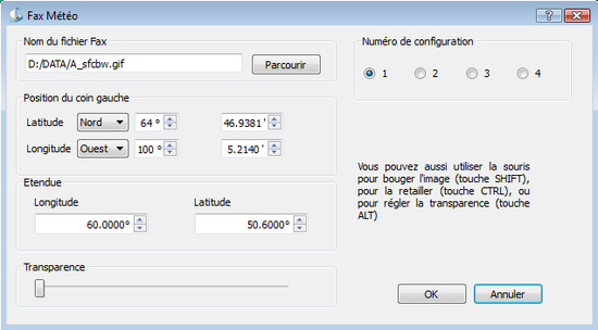
You can also set these parameters directly in the meteo-fax dialog box:
This operation requires a bit of care and focus
The good news is that it has to be done only once, since qtVlm will memorize the settings for a given meteo-fax, based on the file name. So the next time you will open a meteo-fax with the same name, qtVlm will position it correctly immediately
This is convenient since meteo-faxes generated daily by NOAA always have the same name.
You can define up to 4 different meteo-fax configurations with the help of Preset number
Comparing a meteo-fax and a grib
- Open a meteo fax like described above.
- Load a grib file.
- Set the grib date to the date of the meteo-fax.
- Compare the two sources.
If the meteo-fax and the grib are close, it means that the forecaster estimate that the grib is reliable.
If the meteo-fax is locally different from the grib (for instance with a bigger low pressure), it means that the meteorologist has decided that the grib model is not reliable.
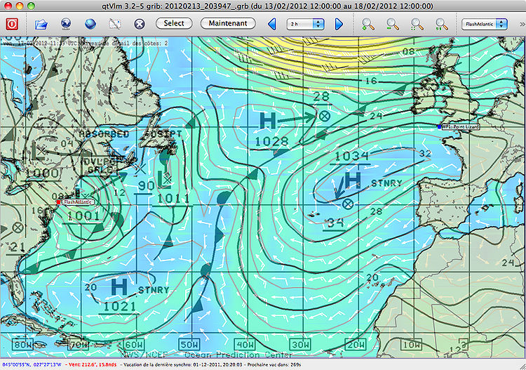
Hereafter a meteo fax at 96h and a grib GFS at the same date for North Atlantic
In these case, the 2 information are almost identical.
This is not always the case.
If differences occur, it is advised to favor the meteo-fax instead of the grib file in order to decide for a route.
This function in qtVlm has a limited interest for VLM players. On the contrary, it is very useful for a real sailor, on a real boat navigating on a real ocean.
--jpla 13 février 2012 à 23:05 (CET) translated by maitai


